By Mayara Subtil*
- Despite the national improvement, the Cerrado has been Brazil’s most deforested biome for the third consecutive year since 2019, accounting for more than half (55%) of the country’s total deforested area in 2025, even though it covers only about 24% of the national territory.
- For the first time ever, Brazil recorded less than 1 million hectares of deforestation in 2025; the deforested area fell by 21% compared to 2024, and all biomes showed a reduction.
- The Cerrado lost 540,000 hectares of native vegetation in 2025, a 17% decrease compared to 2024.
- In 2025, 72% of deforestation in the Cerrado occurred in savanna formations, the biome’s typical vegetation.
- Matopiba accounted for 40% of the country’s deforestation and 70% of the Cerrado’s deforestation in 2025, despite a 24% decrease compared to 2024.
- Guadalupe, in southern Piauí, ranked first for the first time among the most deforested municipalities in the Cerrado, recording a 228% increase in deforested area and a 1,978% expansion of agriculture and livestock farming in the municipality.
In 2025, the Cerrado accounted for 55% of all deforested area in Brazil. The loss amounted to just over 540,000 hectares of native vegetation, a 17% decrease compared to 2024. The deforested area is roughly equivalent to the entire territory of the Federal District. Although the index shows a decline, the biome has led the national deforestation ranking for the third consecutive year and continues to experience a greater loss of forest cover than that recorded in other Brazilian biomes.
The data are part of RAD2025 (Annual Report on Deforestation in Brazil), released this Wednesday (27), with information produced by researchers from IPAM (Amazon Environmental Research Institute) for the Cerrado biome and part of the MapBiomas network.
The reduction observed in 2025 continues the trend of slowing deforestation in the Cerrado in recent years, albeit at high levels, with more than 4.5 million hectares deforested since the launch of the deforestation alert validation system, MapBiomas Alerta, in 2019. In 2023, the biome surpassed the 1.1 million-hectare mark for deforestation. By 2024, however, the loss of native vegetation had fallen by 41% compared to the previous year.
Nationally, Brazil recorded, for the first time since measurements began, less than 1 million hectares of deforestation in a single year, with 984,794 hectares deforested across the entire Brazilian territory in 2025. Compared to last year, there was a 21% decrease in the deforested area, and all biomes showed a reduction in their rates of native vegetation loss.
“This reduction in deforestation in the country reinforces the importance of continuous remote monitoring, transparency, and environmental enforcement actions, especially at this time of scrutiny regarding Brazilian environmental legislation and its enforcement mechanisms. In the Cerrado, where half of the native vegetation still remains, maintaining and strengthening these actions is essential to halt the loss of the biome’s native vegetation, which supports the country’s biodiversity, agricultural production, and water security,” noted Julia Shimbo, a researcher at IPAM.
Even though it is the country’s largest biome and covers an area roughly twice that of the Cerrado, the Amazon recorded deforestation estimated at nearly 290,000 hectares in 2025, a figure 23% lower than that observed in 2024. The Caatinga, in turn, lost approximately 128,000 hectares during the period, a decrease of about 26% compared to the previous year. Meanwhile, the Pantanal, Pampa, and Atlantic Forest saw reductions of 48%, 34%, and 5%, respectively.
The savanna formation, typical of tropical regions marked by well-defined dry and rainy seasons, was, for the third consecutive year, the most affected vegetation type in Brazil. In the Cerrado alone, 72% of the loss of native vegetation in 2025 occurred in this type of vegetation, which accounts for 28% of the biome’s cover. About 25% of deforestation occurred in forest formations and 3% in grassland formations within the biome.
In addition, agriculture and livestock farming remain the main driver of deforestation pressure on the Cerrado, accounting for 99.5% of the loss recorded in the biome last year, equivalent to 573,000 hectares. The remaining drivers account for 0.5% of the deforested area and include roads, mining, renewable energy, aquaculture, reservoirs, and urban expansion. Of the 2,915 hectares deforested due to urban expansion, 35% are in the Cerrado.
Matopiba: one of the critical regions
Despite the reduction compared to 2024, Maranhão remained the state with the largest deforested area in the Cerrado and the country for the third consecutive year. In 2025, it recorded a loss of 154,000 hectares of the national total. Next are Piauí, with a loss of over 114,000 hectares; Tocantins, with over 100,000 hectares deforested; and Bahia, with 71,000 hectares lost. These states make up Matopiba, an agricultural frontier region that accounts for a large portion of deforestation in the Cerrado.
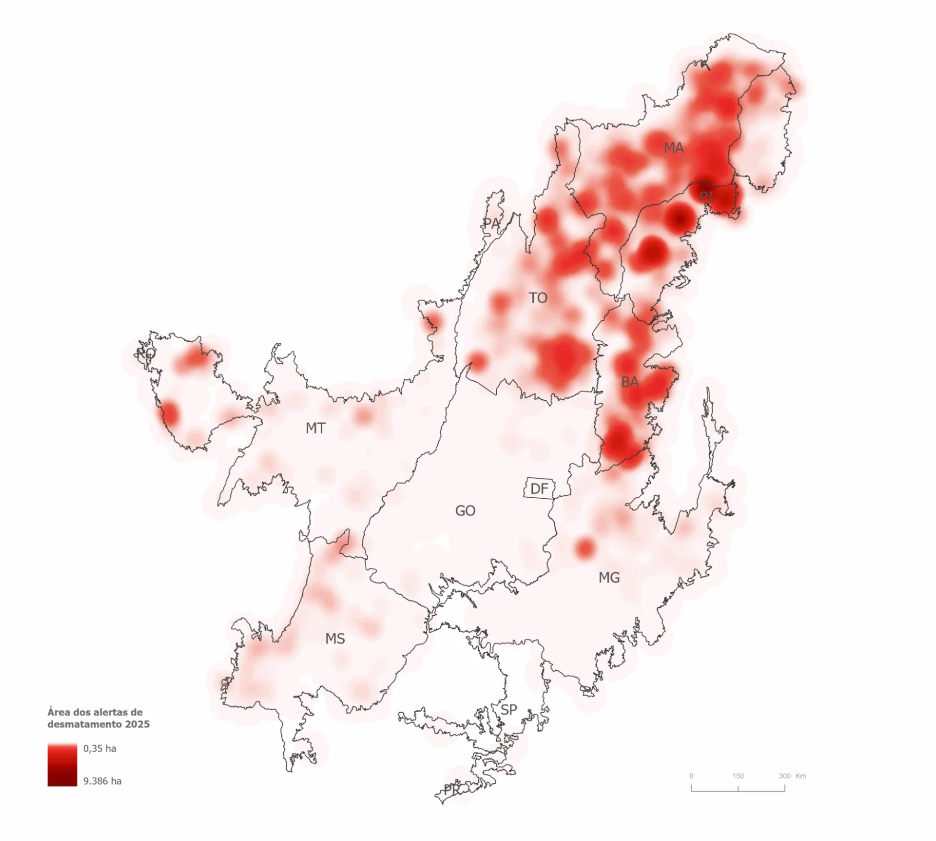
Concentration of deforestation in the Cerrado in 2025. Photo: Courtesy of IPAM
Even with a 24% decrease in the loss of native vegetation compared to 2024, Matopiba accounted for 392,000 hectares of deforestation in 2025, representing 40% of the country’s total deforestation and 70% of native vegetation loss in the Cerrado. All 10 of the biome’s most deforested municipalities are located in the region.
According to IPAM Executive Director André Guimarães, “the world no longer tolerates deforestation because, together with climate change, it jeopardizes food production.” “Matopiba should be viewed as a strategic repository of native vegetation to stabilize the climate and ensure rainfall for agriculture, not as a frontier for the expansion of deforestation. At the same time, we need to create incentive and compensation mechanisms for people who help conserve the region’s native vegetation,” he said.
The advance of vegetation clearance in the Cerrado, especially in Matopiba, reinforces warnings about the environmental and economic impacts of the loss of native areas, considered essential for the country’s climate and water regulation.
“This scenario jeopardizes the integrity of the biome, which has already lost about half of its native vegetation, especially in recent decades,” added Ane Alencar, director of Science at IPAM.
Most Deforested Municipalities
For the first time, the municipality of Guadalupe, in southern Piauí, ranks as the most deforested municipality in the Cerrado. The city recorded a loss of 17,000 hectares of native vegetation in 2025 and saw a 228% increase in deforested area compared to 2024.
Land use and land cover data from MapBiomas Collection 10.1 reveal rapid expansion of agriculture and livestock farming in Guadalupe. Among the key indicators is a 1,978% increase in the area occupied by this activity in the municipality, accompanied by a 5% reduction in native vegetation, considering the period from 1985 to 2024.
“The fact that Guadalupe appears, for the first time since the beginning of the MapBiomas Alerta historical series, as the most deforested municipality in the Cerrado highlights the advance of native vegetation clearance in new areas of the biome. Furthermore, it reinforces the pattern of deforestation concentration in the transition regions between the Cerrado and the Caatinga, something we have observed more recently,” noted Roberta Rocha, a science researcher at IPAM.
Another highlight is the municipality of Baixa Grande do Ribeiro, also in Piauí, where the second-highest deforestation rate in the country was recorded (with the highest deforestation rate in the country located in the municipality of Canto do Buriti, in the Caatinga) in a single alert in the Cerrado. Between September 2024 and May 2025, 9,300 hectares were deforested in the region, equivalent to 13,000 soccer fields the size of the Maracanã Stadium field in Rio de Janeiro.
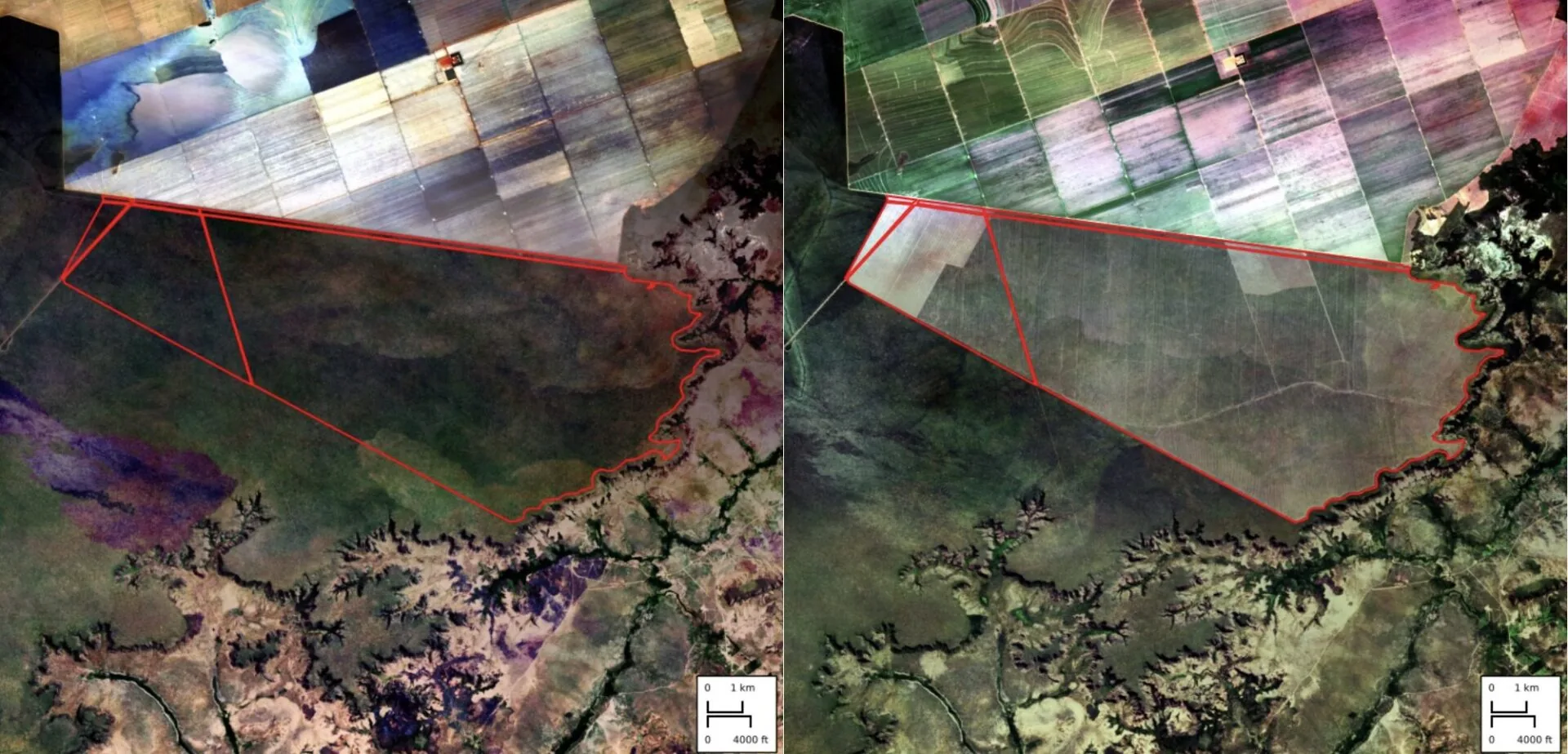
Before-and-after images from September 2024 to May 2025 of the largest deforestation alert in the Cerrado in 2025, in the municipality of Baixa Grande do Ribeiro in Piauí. Photo: Reproduction/MapBiomas Alert.
The alert with the highest average daily deforestation rate in the Cerrado—that is, the area being deforested the fastest in the biome—was identified in the municipality of Nova Lacerda, in the state of Mato Grosso. Over a 38-day period, 2,514 hectares were deforested, equivalent to an average of 66.2 hectares lost per day.
RAD and MapBiomas Alert
MapBiomas’ RAD compiles consolidated deforestation data from across Brazil. It analyzes deforestation alerts detected between 2019 and 2025, which have been validated and refined using high-resolution satellite imagery by MapBiomas Alert.
In this seventh edition, in the Cerrado, the alerts generated by DETER (INPE’s Real-Time Deforestation Detection System) and SAD Cerrado (IPAM’s Cerrado Deforestation Alert System), developed by IPAM, and the alerts generated in the transition regions between biomes by SAD Caatinga (Caatinga Deforestation Alert System, by UEFS and Geodatin), SIRAD-X (Radar-based Deforestation Indication System in the Xingu Basin, by ISA), SAD Imazon (Amazon Deforestation Alert System, by Imazon), SAD Mata Atlântica (Atlantic Forest Deforestation Alert System, by SOS Mata Atlântica and ArcPlan), and SAD Pantanal (Pantanal Deforestation Alert System, by SOS Pantanal and ArcPlan), were used to locate deforestation alerts in daily high-resolution satellite images.
All data is made publicly available free of charge on a web platform so that enforcement agencies, financial institutions, companies, and civil society can take action to reduce illegal deforestation. The full report with all the data is available on the MapBiomas Alerta website (alerta.mapbiomas.org).
*IPAM Communications Analyst. mayara.barbosa@ipam.org.br