Tainá Andrade*
The MapBiomas network, of which IPAM (Instituto de Pesquisa Ambiental da Amazônia) is a part, launched on Friday (5) the third collection with an unprecedented mapping of Brazilian soil properties, which will allow, among other advances, analysis at depths of up to 100 cm and the stock of organic carbon in the soil. In addition, the SoilData platform was inaugurated, which brings together soil data from hundreds of studies, ready for reuse and to support decision-making in strategic sectors such as farming, agriculture and land protection.
“Having this data available sheds light on a compartment that plays a decisive role in environmental policies: soil. It is a key element in the context of the climate emergency, for example, because it can be both a source of carbon emissions and a sink. It’s an extremely important part of the system, but it’s not always on the agenda,” explained Bárbara Costa, a research analyst at IPAM.
0-30cm
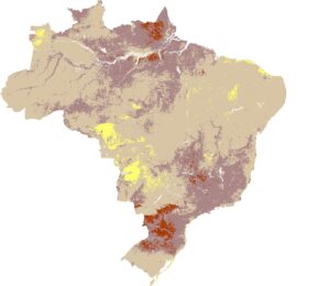
30-60 cm
60-100 cm
Maps with spatial visualization of the granulometry of Brazilian soils, produced by the data compiled in SoilData. Source: MapBiomas/IPAM
With the information gathered in SoilData, it was possible to generate maps of soil properties for the whole of Brazil, such as granulometry, texture, stoniness and soil organic carbon. In this collection, a total of 60,883 granulometry data and 28,065 organic carbon stock data were used for mapping, an increase of around 32% compared to the previous collection, launched in 2024.
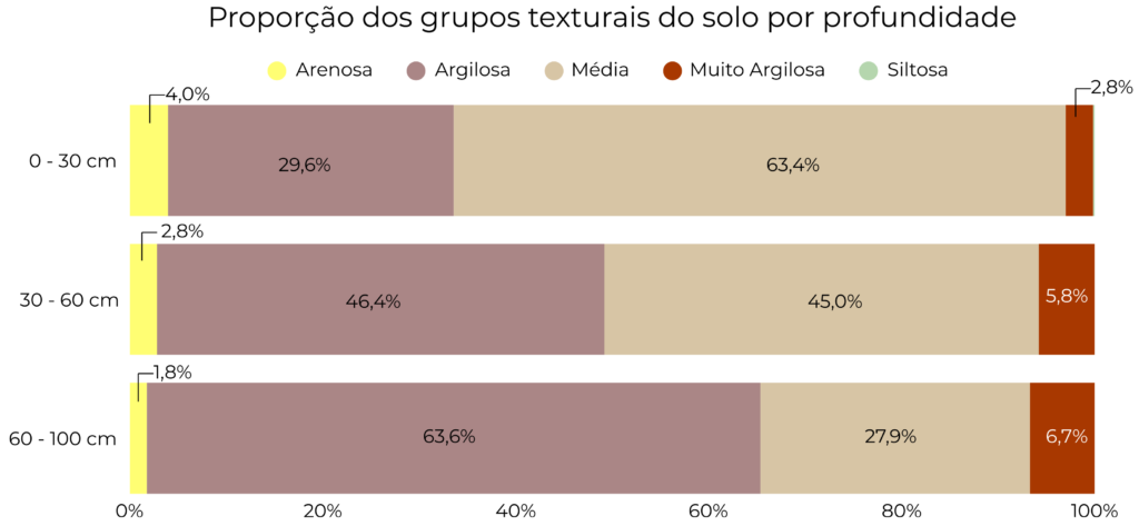
The results show that more than half of Brazil (63.4%) has a medium texture in the surface layer (0-30 cm). Clay soils appear in second place (29.6%), while sandy, silty and very clayey textures account for only 7% of the national territory. The distribution of textures varies between biomes: in the Atlantic Forest, 52% of surface soils are very clayey, a very different proportion from biomes such as Caatinga, Cerrado and Pampa, where medium texture predominates. Between 60 and 100 cm deep, the country becomes mostly clay (63.6%).
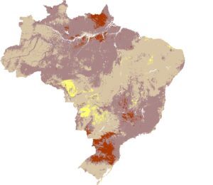
Mapping of textural classes in Brazilian territory up to 100 cm deep. Source: MapBiomas/IPAM
Historically, very clayey soils are the most used for agriculture and will occupy 33% of this texture in 2024. It is the only textural class of soil where agriculture outweighs pasture. This is a reflection of the favorable physical conditions of clay soil for root development, greater nutrient storage capacity and greater structural stability, reducing erosion and favoring management.
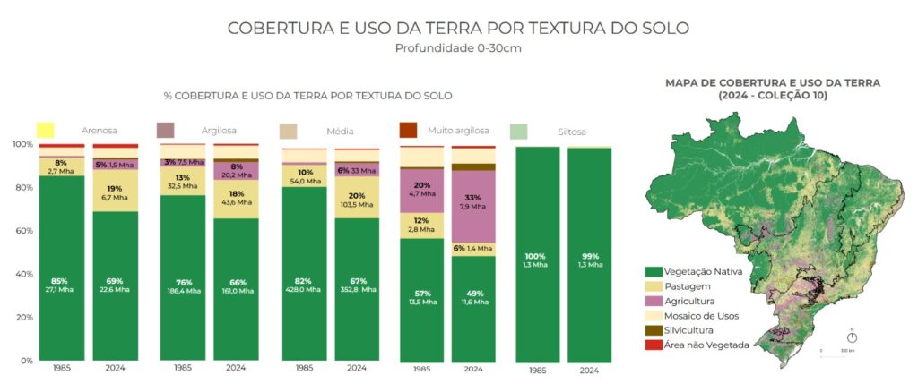
Graph showing land use according to soil textural classes up to a depth of 30 cm. Source: MapBiomas/IPAM
“In general, most of the information we had about the soil covered the surface layer, but at depth we get a better understanding of how the soil works beyond the surface. Soil that is more clayey at depth means that there is an increase in the clay content in the profile. In Brazil, it goes from 2.8% of the soil being very clayey in the 0-30 cm layer to 6.7% of the soil being very clayey in the 60-100 cm layer. Knowing this information can help with everything from construction planning, for example, thinking about foundations, to agricultural management, root development and nutrient availability,” adds Costa.
Soil organic carbon stock
Another set of maps presented shows the stock of soil organic carbon (COS), which indicates the amount of carbon stored up to 30 cm deep. The historical series reveals how the layer of soil most affected by human activities has been storing carbon over the years.
“With this data we seek to understand how much carbon is stored in the soil between 1985 and 2024. The maps act as a snapshot of each year, especially if we consider changes in land use. Monitoring soil carbon stocks provides valuable information for land management. This data helps, for example, to assess the quality of the pasture, identify whether the soil is managing to accumulate carbon and locate areas with a higher or lower stock in order to guide management and conservation actions,” said the analyst.
Currently, 35.9% of Brazilian soils store between 40 and 50 tons of carbon per hectare (t/ha). This stock results from the decomposition of organic matter that reaches the soil and is incorporated by living organisms such as ants, termites and other microorganisms. Organic matter remains in the soil until some disturbance, natural or caused by human activity, causes it to be released as a gas, contributing to greenhouse gas emissions.
Of the 37.5 gigatonnes (Gt) of organic carbon stored in the country’s soil, 3 Gt are in agricultural areas and 16 Gt in forest areas. In 2024, the Amazon concentrated 52% of all COS stored in Brazil. The Caatinga and Pantanal are the biomes with the lowest stock per hectare (32.7 and 35.3 t/ha, respectively).
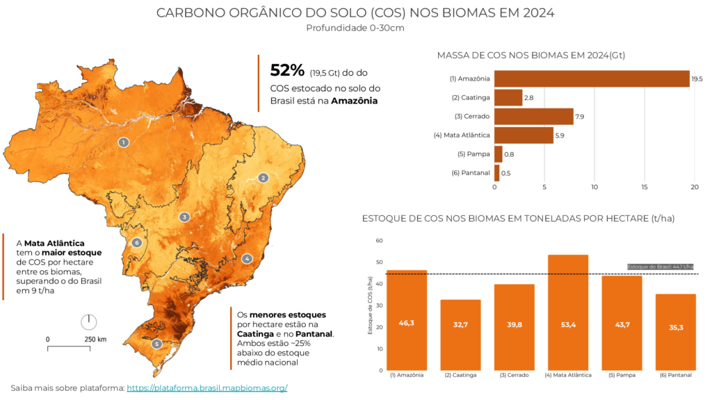
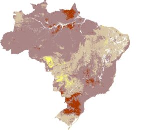
Mapping of soil organic carbon stocks for Brazil and the biomes in total mass (Gt) and in tons per hectare (t/ha). Source: MapBiomas/IPAM
“Brazilian agriculture presents different scenarios when it comes to soil organic carbon. A large part of agriculture today adopts the no-till system, which helps protect and maintain carbon in the soil. On the other hand, degraded pastures can release stored carbon, while well-managed pastures can capture carbon from the atmosphere and store it in the soil. The balance between human action and natural processes is fundamental,” said Bárbara Costa.
Historical data
Collection 3 of MapBiomas Solo presents a platform that brings together standardized soil data from hundreds of studies in all of the country’s biomes, carried out over 66 years. All the data goes through a rigorous process of curation and harmonization before being made available to the public. More than 45,000 collections from different sources have been catalogued, distributed at more than 15,000 points across the country. This collection is strategic not only for economic sectors, but also for environmental research, impact assessments and studies on how changes in territory and land use affect the Brazilian soil.
“We’re talking about data produced long before we were born. We have curated, organized and returned to society a set of information that until then did not exist in an integrated way in Brazil. The gain is not only for the scientific community, but also for sectors that can use this data to produce their own analyses and maps. Agriculture is the first to have direct application, but academia can develop countless research projects using this collection. Another example is water monitoring, for which understanding the characteristics of the soil is fundamental. The same goes for biodiversity and native vegetation studies. There are many benefits to this curation, going far beyond the economic dimension,” says the IPAM researcher.
Most of the samples are in the Amazon (42.7%), followed by the Atlantic Forest (25%) and the Cerrado (approximately 15%). The platform offers intuitive spatial visualization, thematic filters and direct access to information, always with proper acknowledgement of the authors. The aim is to provide data ready for immediate use in analysis, cross-referencing, mapping and spatial modeling to support strategic decision-making in different sectors.
The SoilData platform is available at: https://brasil.mapbiomas.org
*IPAM Communications Analyst