By Lucas Guaraldo*
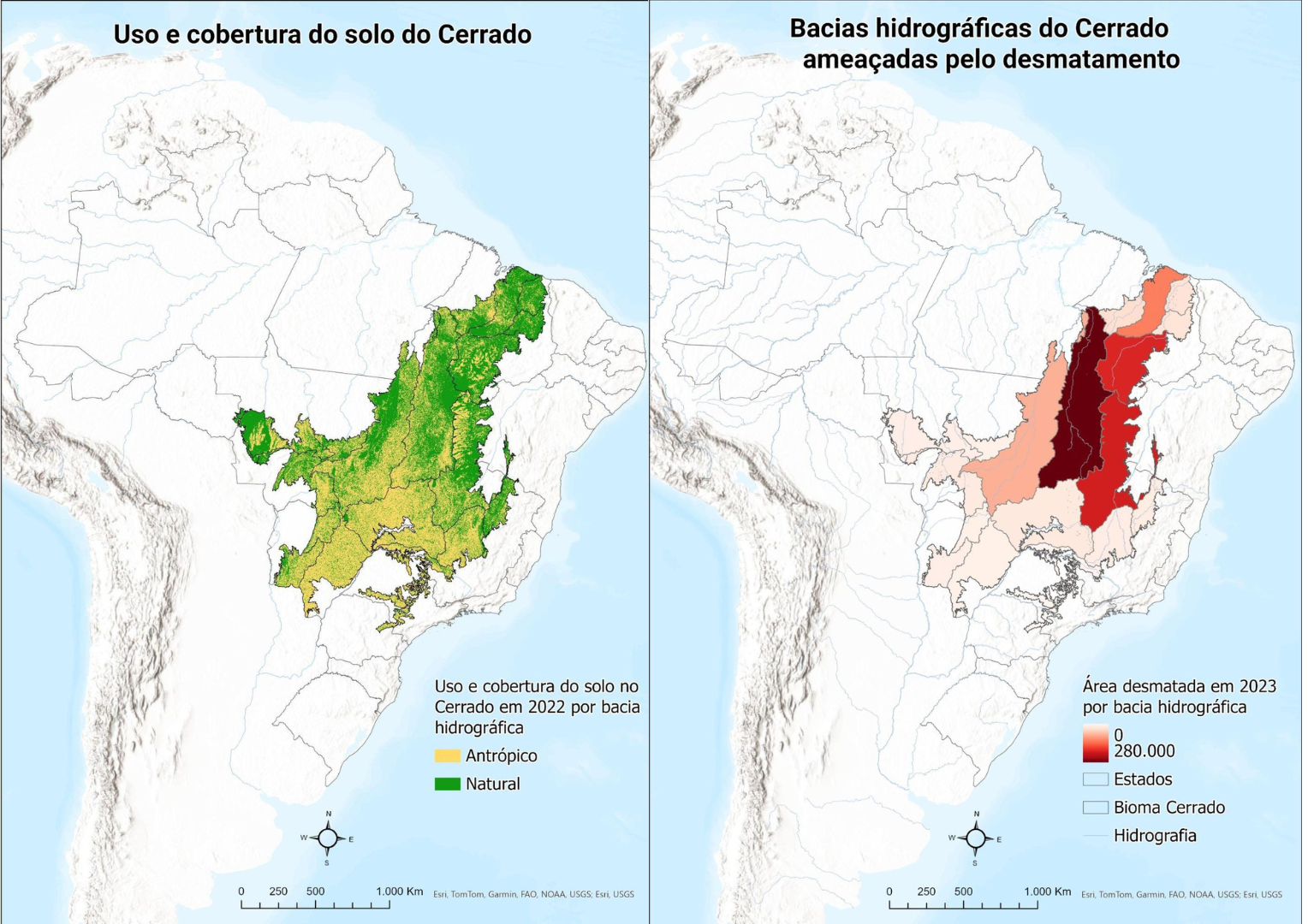
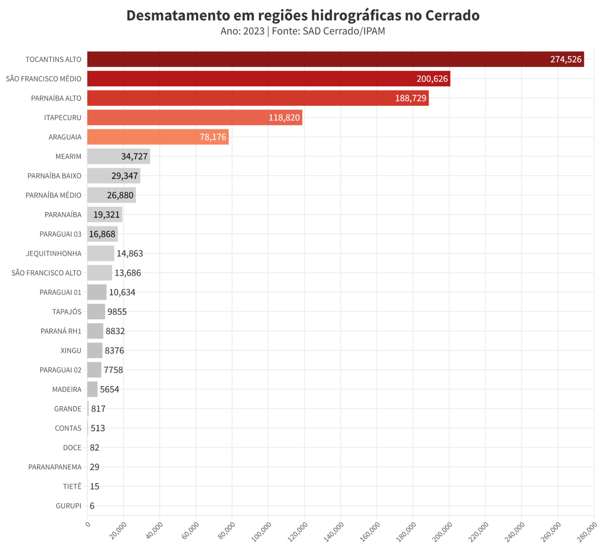
In 2023, 81% of deforestation in the Cerrado was concentrated in the regions supplied by the Upper Tocantins, Middle São Francisco, Upper Parnaíba, Itapecuru and Araguaia river basins, potentially raising the water risk of 373 municipalities in the region. The data was published on Friday by SAD Cerrado (Cerrado Deforestation Alert System), developed by IPAM (Amazon Environmental Research Institute).
Known as Brazil’s water tank because it is home to eight of Brazil’s twelve main hydrographic regions, the Cerrado has reduced its capacity to absorb and retain water due to the loss of native vegetation. The high rates of deforestation in these areas can impact negatively on water resources, such as lowering the water table and increasing the risk of water scarcity.
“Deforestation directly affects water resources, and recent studies show a decrease in the flow of rivers in the Cerrado in recent years due to high rates of deforestation in the biome. This reduction could impact the water supply of cities, electricity production, and agriculture,” warns Fernanda Ribeiro, coordinator of SAD Cerrado and a researcher at IPAM.
These basins are located in the north of the Cerrado and in the Matopiba region, where large areas of deforestation and the sources of Brazil’s main rivers, such as the Araguaia and Tocantins rivers, are concentrated. The region also concentrates most of the biome’s remaining native vegetation.
Basins most affected
In the Upper Tocantins basin, the second largest in the Cerrado basin and the most deforested in 2023, the native vegetation lost 274,000 hectares – 26% of all that was lost in 2023. The basin is home to the headwaters of the Tocantins River, Brazil’s second largest, and it is a key trade route for the flow and irrigation of agricultural production in the country’s central region.
The Middle São Francisco basin, the sixth largest in the country and the second most deforested in 2023 in the Cerrado, lost 200,000 hectares of native vegetation – 14.4% of all deforestation last year in the biome. This basin is home to the main tributaries of the São Francisco River, which stretches for 2,863 km, supplies more than 15 million inhabitants and has four power plants that together produce an estimated 9.9 million kilowatts, but is threatened by increasingly frequent droughts.
The Alto Parnaíba basin had 189,000 hectares of its vegetation deforested – around 13% of the biome’s deforestation in 2023. The basin is home to the headwaters of the Parnaíba River, located in the central region of Matopiba. This region is dominated by large estates, with an increasing use of water to irrigate their production. In 2023, a National Park was created to protect its springs, but this conservation effort still seems to be insufficient to conserve the region’s water resources.
“The protection of the Cerrado’s watersheds depends on a better understanding and characterization of the biome’s water destination, combined with an integrated strategy between the public and private sectors. In addition, it is necessary to implement and reinforce public policies that promote the conservation of remnants of native vegetation and the restoration of degraded areas in strategic locations in the watersheds,” Fernanda said.
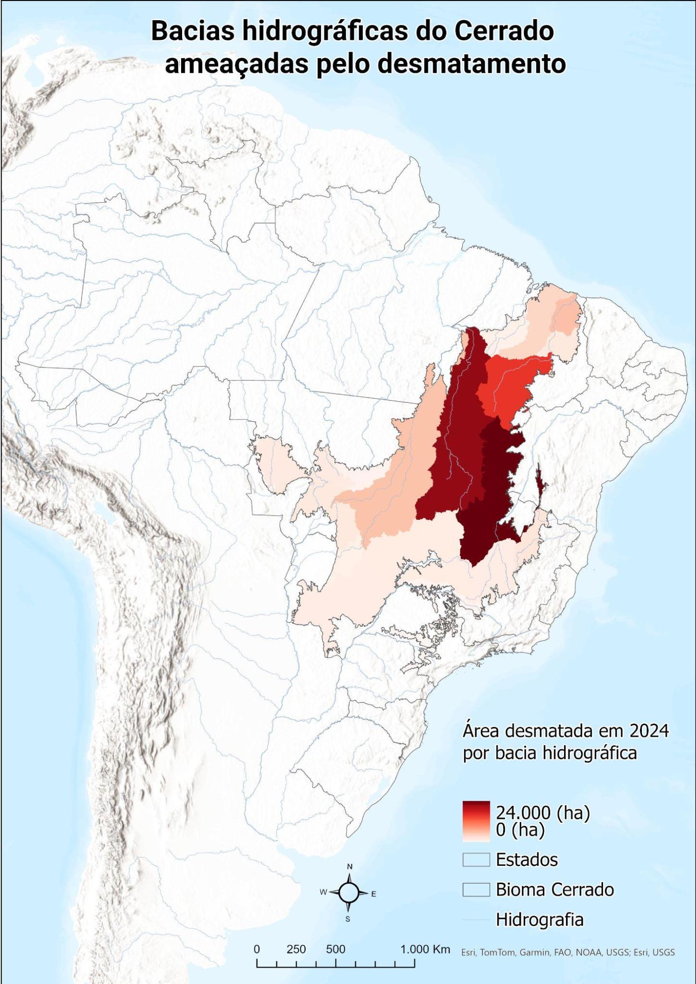
Scenario in 2024
In February 2024, SAD Cerrado detected 38,000 hectares of deforestation in the Cerrado, a reduction of 52% compared to February 2023, when deforestation totaled 79,000 hectares. The states most affected were Tocantins, with 10,000 hectares deforested, Bahia, with 8,000 hectares deforested and Piauí, which lost 5,000 hectares of native vegetation. The municipality of Cocos, located in the west of Bahia, was responsible for the largest deforested area, with a total of 3,000 hectares cleared.
Concerning the river basins, the scenario is repeated in the first two months of 2024. In the first two months of the year, the Cerrado has already accumulated 89,000 hectares deforested. Of this total, 83% is concentrated in five of the Cerrado’s twenty-four river basins (Middle São Francisco with 24,000 hectares; Upper Tocantins with 22,000 hectares; Upper Parnaíba with 15,000 hectares; Lower Parnaíba with 6,000 hectares and Araguaia with 5,000 hectares deforested).
About SAD Cerrado
The Cerrado Deforestation Alert System is a monthly, automatic monitoring project that uses optical satellite images from the European Space Agency’s Sentinel-2 sensor. SAD Cerrado is an analytical tool that provides native vegetation suppression alerts for the entire biome, providing information on deforestation in the biome since August 2020.
A deforestation alert is confirmed by identifying at least two records of the same area on different dates, with a minimum interval of two months between satellite images. The method is detailed on the SAD Cerrado website.
The alert reports for February and previous periods are available at this link. In the interactive panel, it is possible to select states, municipalities, land categories and the time interval for analysis.
The system aims to provide alerts of deforestation greater than one hectare, updated month by month. Researchers believe that SAD Cerrado is a complementary tool to other deforestation alert systems in the biome, such as INPE’s (National Institute for Space Research) DETER Cerrado, optimizing the detection process in visually complex contexts.
Access the georeferenced data by clicking here.
IPAM journalist, lucas.itaborahy@ipam.org.br*