Lucas Guaraldo*
Rural properties with a CAR (Brazilian Rural Environmental Registry) accounted for 75% of all deforestation alerts detected in the Cerrado in 2023, a loss of 879,000 hectares of native vegetation. The data was released on Tuesday by SAD Cerrado (Cerrado Deforestation Alert System), developed by IPAM (Amazon Environmental Research Institute). The area deforested within these properties is equivalent to almost 6 times the size of the city of São Paulo.
Currently, 62% of the Cerrado’s native vegetation is inside rural properties subject to the rules of the Brazilian Forestry Code, which allow the deforestation of 80% of the total area of properties in the biome outside the Legal Amazon. Furthermore, although the biome covers a quarter of the entire national territory, only 12% is under some form of protection – be it conservation units, indigenous territories or quilombola territories – and only 3% of the biome is fully protected by Conservation Units.
“Unlike the Amazon, most deforestation in the Cerrado occurs on private rural properties, but it is also on these properties that most of the remaining native vegetation in the biome is concentrated. To reduce deforestation in these areas, the deforestation licensing system needs to be strengthened and made more transparent. In addition, the Forestry Code needs to be strengthened by validating the CAR, as well as establishing policies aimed at encouraging conservation in private areas,” says Tarsila Andrade, a researcher at IPAM.
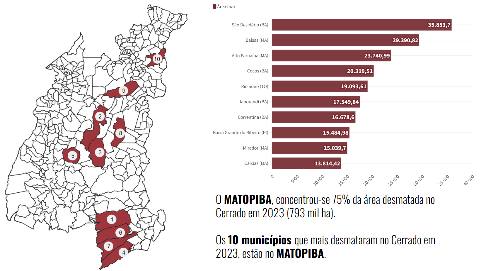
In Matopiba, Brazil’s main agricultural frontier, large properties accounted for around 36% of deforestation alerts, while medium and small properties accounted for 23% and 16%, respectively. In 2023, the Matopiba region was responsible for 75% of all deforestation in the Cerrado, around 793,000 hectares. The region concentrates the largest remnants of the biome and the municipalities that registered deforestation alerts in the year.
The categorization of the size of rural properties is defined by INCRA (Brazilian National Institute for Colonization and Agrarian Reform) and based on the number of Fiscal Modules within a property. The size of the modules changes according to the municipality and can vary, in the Cerrado, between 5 and 110 hectares. Small properties are those with up to 4 modules, while large properties have more than 15. Medium properties are those with between 4 and 15 fiscal modules.
In western Bahia, for example, 63% of deforestation alerts in the Cerrado portion of the state were registered on large properties. As a result, the state saw the opening of new Cerrado areas increase by 92% compared to 2022, reaching 159,000 hectares, of which 100,000 hectares were inside large properties.
Accelerated deforestation
Deforestation alerts in the Cerrado point to an affected area of more than 1 million hectares in 2023, a 30% increase on the alerts identified by SAD Cerrado in 2022, when 815,000 hectares of the biome were cleared. Of the 12 months of 2023, 10 registered an increase in the deforested area compared to the previous year.
In Piauí, the area cleared reached 131,000 hectares last year, an increase of 67% compared to 2022, while Tocantins recorded an increase of 37% and 233,000 hectares cleared. In Maranhão, the state that registered the most deforestation alerts in the Cerrado, the increase was 36%, amounting to 308,000 hectares of native vegetation cleared from the biome.
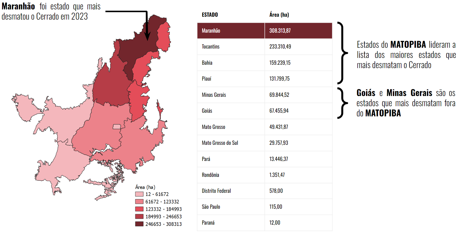
In addition, the ten municipalities that have deforested the Cerrado the most and which account for 19% of all the loss of native vegetation in the biome – around 206,000 hectares – are located in Matopiba, four of which are in the Cerrado in Bahia, four in Maranhão, one in Tocantins and one in Piauí.
“The list of alerts identified by SAD Cerrado shows that deforestation is concentrated in the same states and municipalities. This pattern we have seen of large areas being deforested and concentrated in specific regions is worrying because it can impact the climate, reducing the efficiency of ecosystem services such as the availability of water in the water table, which leads to a lack of water supply for both agriculture and the local population,” says Fernanda Ribeiro, a researcher at IPAM.
São Desidério, the leader in the annual ranking, recorded 36,000 hectares deforested alone – 118% more than in 2022, when the municipality was responsible for converting 16,000 hectares. Balsas, in the south of Maranhão, increased its deforestation by 11%, with the loss of 28,000 hectares.
The municipality with the largest deforested area in Tocantins, Rio Sono, lost 19,000 hectares of native vegetation – 95% more than the deforestation of 2022, rankingfifth . Baixa Grande do Ribeiro, the municipality with the most deforestation in Piauí, lost 15,000 hectares of vegetation, an increase of 201% which placed it in eighth place.
Land protection and organization
Following the trend observed throughout the year, 27,000 hectares of deforested areas were detected in Conservation Units located in the Cerrado – an increase of 93% compared to 2022. The Serra Geral do Tocantins Ecological Station was the reserve hardest hit, having lost more than 6,000 hectares of native vegetation, followed by the Parnaíba River Springs National Park, which lost 5,900 hectares.
The neighboring Conservation Units are part of a mosaic of protected areas that also includes the Jalapão State Park, the Serra da Tabatinga Environmental Protection Area and the Serra da Ibiapaba Environmental Protection Area. The mosaic occupies areas in the heart of Matopiba and has suffered from the pressure of agricultural expansion in the region.
SAD researchers also warn of the advance of deforestation in areas considered to be land voids, i.e. areas with no jurisdiction or clear definition of use. This category totaled 94,000 hectares cleared in 2023 – an increase of 48% compared to 2022, when 64,000 hectares were lost. These areas have no clear domain and it is therefore difficult to fit them into public policy projects for the region.
“Given that more than half of the remaining native vegetation is under private ownership, new conservation strategies that include private areas, such as economic incentives for landowners to give up the right to deforest, are essential for maintaining biodiversity and ecosystem services in the Cerrado. This involves making incentives feasible and forging alliances with open dialogue between the public and private sectors, as well as the participation of civil society and local communities,” says Fernanda.
About SAD Cerrado
The Cerrado Deforestation Alert System is a monthly, automatic monitoring project that uses optical satellite images from the European Space Agency’s Sentinel-2 sensor. SAD Cerrado is an analytical tool that provides alerts on the suppression of native vegetation, providing information on deforestation in the biome since August 2020.
A deforestation alert is confirmed by identifying at least two records of the same area on different dates, with a minimum interval of two months between satellite images. The method is detailed on the SAD Cerrado website.
The alert reports for 2023 and previous periods are available at this link. In the interactive panel, it is possible to select states, municipalities, land categories and the time interval for analysis.
The aim of the system is to provide alerts of deforestation greater than 1 hectare, updated month by month. Researchers believe that SAD Cerrado is a complementary tool to other deforestation alert systems in the biome, such as DETER Cerrado, from INPE (National Institute for Space Research), optimizing the detection process in visually complex contexts.
Access the georeferenced data by clicking here.
IPAM journalist, lucas.itaborahy@ipam.org.br*
Cover photo: Maria Alves Garcia**