By Mayara Subtil*
Hotspots in the Manaus metropolitan area and surrounding municipalities have increased over the past ten days, bringing the 2026 total above the historical average for the period. Between October 4 and 14, 5,598 hotspots were recorded—a figure 37 times higher than that observed during the same period in 2025, when 149 hotspots were recorded. According to a survey by IPAM (Amazon Environmental Research Institute), the total also exceeds the 4,385 hotspots detected during the equivalent period in 2023, a year in which the Amazon experienced an extreme drought.
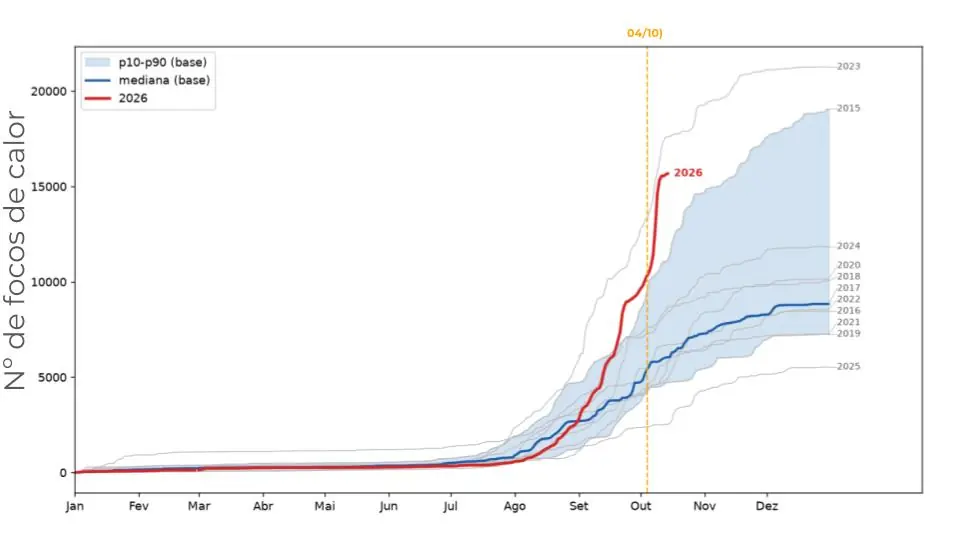
Accumulation of hotspots in the metropolitan and central regions of Manaus from January through October 14, 2026. Photo: IPAM.
Based on data from INPE (National Institute for Space Research), IPAM’s analysis tracks 19 municipalities in the metropolitan and central regions of Amazonas. The survey uses data from the VIIRS sensor aboard the Suomi NPP satellite, released by INPE, to compare hotspots with those from previous years and to identify their distribution across areas of natural vegetation, rural properties, and public lands. It also takes into account alerts regarding deforestation and forest degradation.
Between January 1 and October 14, 2026, the 19 municipalities analyzed recorded a total of 15,674 hotspots, a 109.4% increase compared to the historical average for the same period. This figure is second only to that observed in 2023, among the years analyzed, and shows that the region is exhibiting a pattern similar to that recorded during the Amazon drought that year. The number of hotspots began to rise in August, peaking in September.
In addition, a large portion of the hotspots is concentrated on the right bank of the Amazon River, particularly in the municipalities of Careiro da Várzea and Autazes, near Manaus.
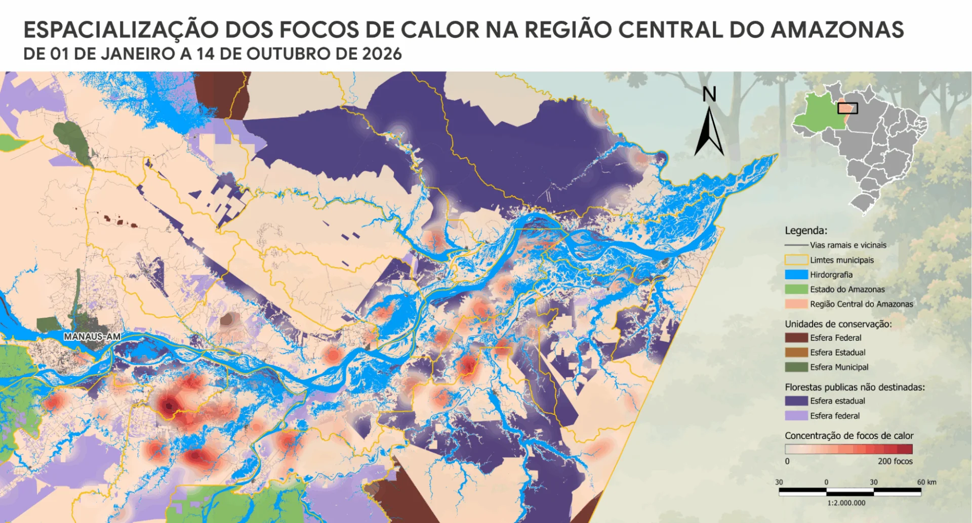
Despite the regional increase, the municipality of Manaus presented a different situation. In the capital of Amazonas, 198 hotspots were identified between January and October 14, 2026, a 3.8% decrease compared to the average of 206 records for the same period between 2015 and 2025. In other words, Manaus accounted for 1.3% of the hotspots identified across the 19 municipalities.
The increase was concentrated primarily in the areas surrounding the capital. Autazes recorded 2,827 hotspots, a 138% increase compared to the historical average, followed by Maués, with 2,431 hotspots (+60%), and Itacoatiara, with 1,639 (+124%). Together, the three municipalities accounted for 44% of the hotspots identified in the region between January and October 14 of this year.
“This increase coincides with the period when the region begins to feel the impacts of the drought caused by El Niño, but it’s important to remember that the drought doesn’t start the fires—people do. The drought facilitates their spread. To prevent further fires in the coming weeks and months, when El Niño tends to intensify, it is essential to reduce the use of fire,” stated Ane Alencar, director of Science at IPAM.
According to Newton Monteiro, a researcher at IPAM, the increase in hotspots “reflects the seasonal pattern expected for this time of year, and 2026 is no exception. However, the scale and speed of this increase are striking: driven by a sharp rise in heat spot records right at the beginning of October, this year’s curve spikes significantly, deviating from the norm of previous years and reaching levels close to those of 2023, when the same region faced an extreme drought.”
More than 300 wildfires have been extinguished in Amazonas over the past five days, according to information from the federal government. After reaching a peak of 494 new hotspots on October 10, the state recorded 188 hotspots on October 16, according to INPE’s “Queimadas” dashboard.
Firefighting efforts involve 330 firefighters, coordinated by Ibama (Brazilian Institute of the Environment and Renewable Natural Resources) and ICMBio (Chico Mendes Institute for Biodiversity Conservation), as well as 11 aircraft, 32 ground vehicles, and eight boats.
Non-Designated Public Forests
FPNDs (Public Forests Without Designated Use) accounted for 39.4% of the hotspots recorded between January and October 14, 2026, in the metropolitan and central regions of Amazonas. These forests belong to the government but have not yet been formally designated for conservation and sustainable use. Among the designations provided for in Brazilian law are the creation of protected areas and the recognition of territorial rights of indigenous peoples and traditional communities.
Another 22.6% of the hotspots occurred on public lands, 57% of which were federal and 43% state-owned. Settlements accounted for 15% of the records, while Indigenous Lands accounted for 6.8%. On private rural properties, 5,155 hotspots were identified, of which 2,018 occurred on large properties, 450 on medium-sized properties, and 2,687 on small properties.
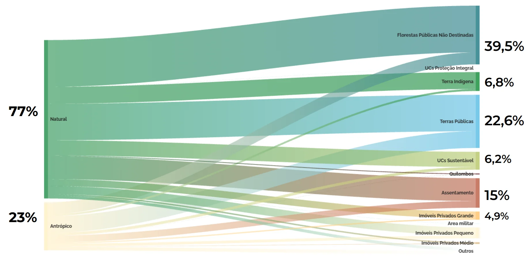
Data on hotspots by land tenure, land use, and land cover in the metropolitan and central regions of Manaus from January through October 14, 2026. Photo: IPAM
The survey also shows that 77% of the hotspots occurred in areas of native vegetation, while 23% were recorded in areas already altered by human activity, such as pasturelands.
“The concentration of hotspots in Public Forests Not Designated for Specific Use is a warning sign of the vulnerability of these territories, which already face pressures related to land grabbing, illegal deforestation, and the use of fire. It is urgent to move forward with designating these forests for conservation and sustainable use, ensuring their governance and protective measures—such as enforcement and integrated fire management—in order to reduce the risks of degradation and wildfires,” emphasized Rebecca Maranhão, a researcher at IPAM.
In the Amazon, about 78% of deforested areas in FPNDs are subsequently converted into pastures, while 22% show vegetation regeneration but remain subject to further degradation and fires. In 2024, amid the extreme drought associated with El Niño, these forests recorded the largest burned area since 2019.
Since tropical rainforests are not naturally adapted to fire, wildfires threaten biodiversity, carbon stocks, and the vegetation’s ability to recover. Designating these areas also helps strengthen enforcement and integrated fire management—measures that contribute to reducing illegal occupation and the risk of new fires.
Municipalities
In addition to Manaus, the survey covers 18 other municipalities in Amazonas: Autazes, Barreirinha, Boa Vista do Ramos, Careiro, Careiro da Várzea, Iranduba, Itacoatiara, Itapiranga, Maués, Nhamundá, Nova Olinda do Norte, Parintins, Presidente Figueiredo, Rio Preto da Eva, São Sebastião do Uatumã, Silves, Urucará, and Urucurituba.
Between January and October 14, 2026, the monitored municipalities recorded 15,674 hotspots. September saw the highest number of occurrences, with 6,861 records, followed by October, which had already totaled 6,183 hotspots as of October 14.
The analysis also takes into account alerts from INPE’s DETER (Real-Time Deforestation Detection System) to track deforestation and forest degradation in the monitored areas.
*Communications Analyst. mayara.barbosa@ipam.org.br
Cover photo: Newton Monteiro/IPAM