By Lucas Guaraldo*
Deforestation in the Cerrado increased by 68%, reaching more than 1.1 million hectares in 2023 and surpassing, for the first time, the losses recorded in the Amazon. The area is equivalent to 61% of all the deforestation recorded in Brazil last year and is equivalent to almost 2.4 times all the deforestation recorded in the Amazon rainforest (454,271 ha). The data was published on Tuesday (28) by the RAD (Annual Deforestation Report) and produced by researchers from IPAM (Amazon Environmental Research Institute) in the MapBiomas Network.
Between 2019 and 2023, 8.5 million hectares of native vegetation were deforested in Brazil, 52% in the Amazon and 39% in the Cerrado. Last year alone, the two biomes, which cover around 73% of the country, together lost around 1.5 million hectares – 85% of all deforestation mapped in 2023. In the list of the 50 municipalities that lost the most native vegetation in 2023, 33 are totally or partially in the Cerrado biome.
Despite the increase in the Cerrado, total deforestation in Brazil fell by 12% in 2023, from just over 2 million hectares in 2022 to 1.8 million hectares in 2023. The Caatinga and Pantanal were other biomes that saw increases of 43% and 59%, respectively. The Atlantic Forest and Pampa, on the other hand, reduced their deforested area by 60% and 50%.
“Fighting deforestation in the Cerrado becomes an extra challenge in a context where legislation is permissive in the biome. That’s why we need to have more transparency and control over the issue of legality so that we can improve and design public and private policies that stop illegal deforestation and discourage legal deforestation, with a view to making more efficient use of the areas that have already been deforested,” warns Ane Alencar, IPAM’s Science Director.
Deforestation in the Cerrado also repeated the same profile as in previous years – around 65% of all the deforested area was lost in large alerts of more than 100 hectares. It was in the Cerrado that researchers recorded the largest deforestation alert in all of Brazil: 6,600 hectares were deforested in a single area, in the municipality of Alto Parnaíba (MA). The municipality of Baixa Grande do Ribeiro (PI), meanwhile, had the fastest deforestation in Brazil, cutting down 944 hectares, the equivalent of 8 Ibirapuera parks, in just 8 days.
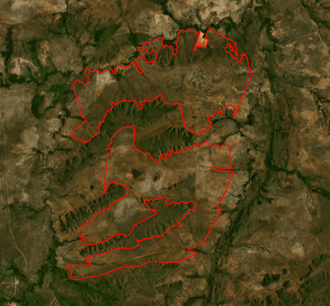
The largest deforestation alert in Brazil was recorded in Alto Parnaíba, in Maranhão, covering 6,600 hectares and detected by SAD Cerrado.
(Source: Planet Imagens, MapBiomas Alerta, IPAM)
Farming, through the opening up of areas for pastures and crops, was the driver of at least 98% of all the deforested area in the Cerrado. In addition, the biome’s savannah formations – characterized by their crooked trees and large presence of shrubs – suffered 74% of all deforestation.
Matopiba leads deforestation
The Matopiba frontier – a region made up of Tocantins and parts of the states of Maranhão, Piauí and Bahia – accounts for 74% of all deforestation in the Cerrado, with 826,805 hectares cleared. Around 47% of all native vegetation cleared in Brazil by 2023 is concentrated in Matopiba. Deforestation in the region was almost twice as high as that recorded in the whole of the Amazon, which lost 454,000 hectares in 2023.
In addition, all 10 of the municipalities that deforested the most in the Cerrado are in this region. São Desidério (BA), the isolated leader in deforestation in 2023, cut down more than 40,000 hectares of native vegetation – an increase of 9% compared to 2022. Balsas (MA), second in the ranking, increased its deforestation by 33%, reaching more than 37,000 hectares felled.
“The Matopiba region is home to the states and municipalities that are leaders in deforestation in the Cerrado and in Brazil, and which occupy prominent positions in the production of grains such as soybeans and corn. In addition, this region has climatic characteristics, terrain and soil conducive to farming. This, coupled with economic investments in the region and technological advances that favor productivity, means that Matopiba concentrates a large part of the Cerrado’s deforestation and is one of the most deforested regions in Brazil,” explains Roberta Rocha, a researcher at IPAM.
States and municipalities
Of the 13 states with Cerrado areas, 10 registered an increase in deforestation in 2023, with Maranhão (111%), Tocantins (182%), Goiás (125%), Pará (270%) and the Federal District (613%) more than doubling the area of vegetation lost compared to 2022. Maranhão, the state with the highest recorded deforestation among all the federation units, and Tocantins, cut down around 320,000 and 229,000 hectares of vegetation in the Cerrado, respectively, totaling 50% of all that was cut down in the biome last year.
“The lack of monitoring of deforestation, as well as few policies and incentives for conservation in private areas, favors deforestation throughout the biome, whose remaining native vegetation is mostly located in private areas, especially in the MATOPIBA region,” says Júlia Shimbo, a researcher at IPAM.
Of the 1,422 municipalities with vegetation cover totally or partially occupied by the Cerrado, 990 (70%) have registered at least one deforestation alert. São Desidério, in western Bahia, which had already topped the list of Cerrado municipalities with the largest deforested area in 2022, was the Brazilian municipality with the most deforestation in 2023: more than 40,052 hectares were cleared in just one year, an increase of 9% compared to 2022.
Barão de Grajaú, a small municipality of 19,000 inhabitants in eastern Maranhão, recorded the largest relative increase in deforestation in the Cerrado. There were 9,720 hectares cleared in 2023, 1,266% more than in 2022, when 711 hectares of vegetation were suppressed. The area cleared in 2023 alone corresponds to 4% of the entire area of the municipality, according to data from the IBGE (Brazilian Institute of Geography and Statistics).
The advance of deforestation in the Cerrado has also caused municipalities that were not previously among the biome’s biggest deforesters to enter the list. Alto Parnaíba (MA), which deforested more than 29,000 hectares, with an increase of 295% compared to 2022; Rio Sono (TO), which increased its deforestation by 864%, exceeding 21,000 hectares; and Cocos (BA), where the area devastated was more than 20,000 hectares, with an increase of 512%.
“The expansion of deforestation into new areas with remaining native vegetation in the biome generates various social and environmental conflicts, with negative consequences for the agricultural sector, such as increased drought and water scarcity, which could be even more serious in a context of climate change,” points out Fernanda Ribeiro, a researcher at IPAM.
About RAD and MapBiomas Alert
The RAD (Annual Deforestation Report), from the MapBiomas network, of which IPAM is a member, gathers consolidated deforestation data from all over Brazil. It analyzes deforestation alerts detected between 2019 and 2023, which have been validated and refined using high-resolution satellite images by MapBiomas Alerta.
In this fifth edition, in the Cerrado, the alerts generated by DETER (INPE’s Real-Time Deforestation Detection System) and SAD Cerrado (IPAM’s Cerrado Deforestation Alert System), and the alerts generated in the transition regions between the biomes, by SAD Caatinga (UEFS and Geodatin’s Caatinga Deforestation Alert System), SIRAD-X (Xingu Basin Deforestation Radar Indication System, by ISA), SAD Imazon (Amazon Deforestation Alert System, by Imazon), SAD Mata Atlântica (Atlantic Forest Deforestation Alert System, by SOS Mata Atlântica and ArcPlan) and SAD Pantanal (Pantanal Deforestation Alert System, by SOS Pantanal and ArcPlan), were used to locate the deforestation alerts in the high spatial resolution daily satellite images.
This is the first year that the RAD includes alerts issued by the Cerrado SAD (developed by the IPAM team, in partnership with LAPIG/UFG and MapBiomas). In total, an area of 243,000 hectares was captured by the system alone, in addition to 567,000 hectares that were detected by both SAD Cerrado and DETER Cerrado. The inclusion of this new deforestation alert system is important because it complements the official deforestation mapping data for the Cerrado, helping to identify deforestation in the Cerrado’s non-forest formations (savannas and grasslands).
In order to identify omissions in the monthly deforestation systems, the polygons from PRODES 2020 (INPE’s Program for Monitoring Deforestation in the Cerrado biome) were included, and the polygons from PRODES 2021 are in the process of being validated.
All the data is made available publicly and free of charge on a web platform so that inspection bodies, financial agents, companies and civil society can take action to reduce deforestation. The full report with all the data is available on the MapBiomas Alert website.
IPAM journalist, lucas.itaborahy@ipam.org.br*
Cover photo: Lucas Guaraldo/IPAM**