By Lucas Guaraldo*
In a meeting with Minister Marina Silva and officials from the Brazilian Ministry of the Environment and Climate Change and the Brazilian Ministry of Agrarian Development, local leaders presented material with the demands and experiences of traditional populations and family farmers about the areas where federal public lands are being allocated. The study prepared by leaders and researchers focuses on the allocation of public areas in the south of Amazonas state as a strategy to combat deforestation and land grabbing in the region, as well as identifying demands in areas already allocated within the municipalities. The aim is to draw attention to social demands and support policies for land allocation and regularization in the municipalities.
Despite a 50% reduction in deforestation in the Amazon compared to the previous year, municipalities in the south of Amazonas saw deforestation increase in 2023. According to the researchers involved in the project, earmarking public land for conservation could drastically reduce deforestation and emissions from cutting down forests, protecting local biodiversity and natural resources.
“With this study, it’s possible to calculate the carbon emissions that stop occurring as a result of setting aside these areas and also to map the species and springs protected by this process. We visited these municipalities and saw places that had lost 80% of their water. This disappearance of rivers, especially in the Cerrado, but which also affects the south of the Amazon, is worrying. Without water, we’re not going anywhere,” said Paulo Moutinho, senior researcher at IPAM (Amazon Environmental Research Institute) and one of the authors of the study.
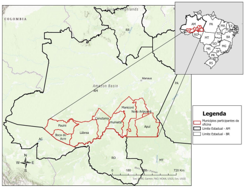
Region of Amazonas in which the municipalities studied are located
.
The research involved scientists from IPAM, IEB (International Education Institute of Brazil), WCS (Wildlife Conservation Society), Idesam and the Alliance for the Sustainable Development of Southern Amazonas (ADSSA). Residents’ reports were collected during the workshop “Building sustainable and collective solutions for the undesignated areas of southern Amazonas”, which mapped the demands focused mainly on the region’s undesignated public forests.
Listening to the people
During the collection process, local representatives from eight municipalities were heard: Apuí, Boca do Acre, Canutama, Humaitá, Lábrea, Manicoré, Novo Aripuanã and Pauini. In all, the area included in the population’s demands amounts to 9.5 million hectares of Amazon rainforest that could be earmarked for conservation, the creation of settlements, the demarcation of indigenous lands or land regularization.
Participants also reported cases of violence suffered by small producers, indigenous people and local communities as a result of the invasion and grabbing of public lands. Among the main attacks suffered by residents are assassination attempts and intimidation of rural leaders, environmental depredation and eviction of residents.
To ensure that popular demands were duly registered, the Socio-environmental Public Spaces methodology was included alongside social cartography, based on participatory consultation and the representativeness of social demands. Land law workshops were also given, with the aim of explaining Brazil’s land history and developing a social mapping that would give more visibility to the fragile populations of the demands on their territory.
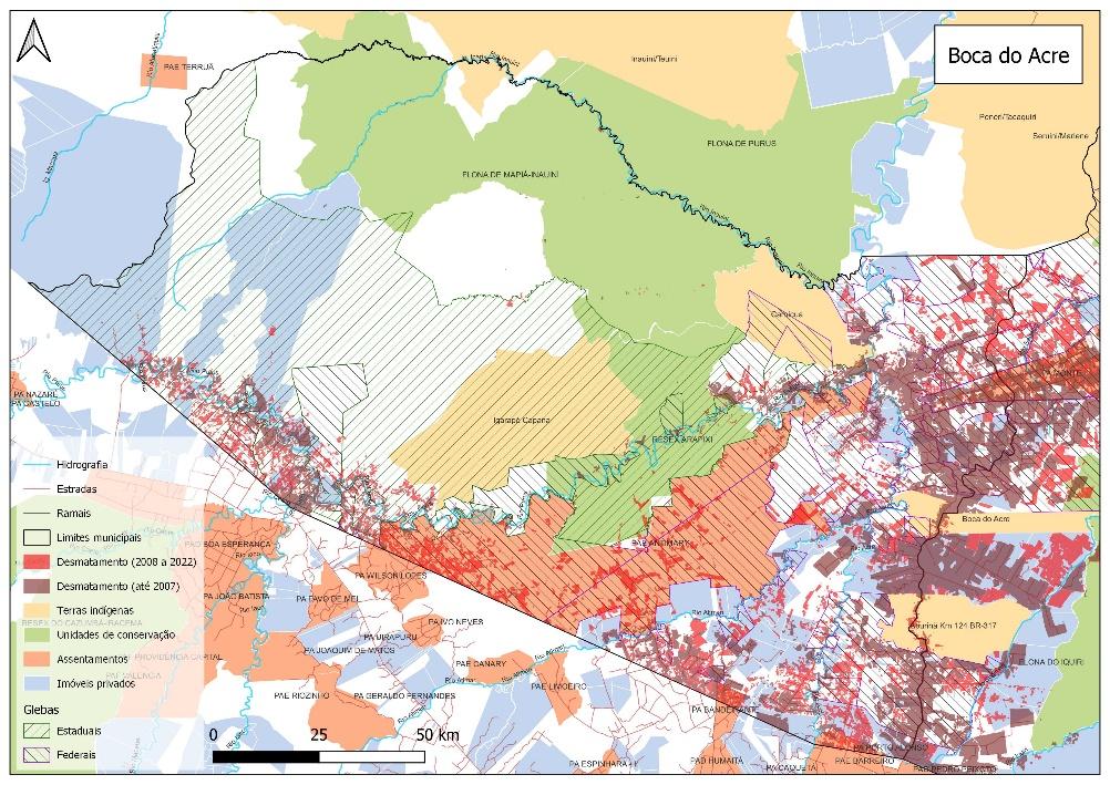
Map of Boca do Acre used during the workshop to define critical points in the municipality
.
“The activities made it possible for leaders to be autonomous, as they indicated on the maps a wide range of information about the territory they occupy. They pointed out conflicts, the location of traditional peoples and communities, indigenous peoples and economic activities, as well as the need for recognition, land regularization and the allocation of public areas in these territories. Both the land rights workshop and the participatory cartography workshop were important for giving the leaders a voice, but they also helped them gain a better understanding of the space they occupy,” said Josimar Fidelquino, ADSSA’s executive secretary, and Rebecca Maranhão, an IPAM researcher who also signed the note.
The activities also served to further highlight the advance of deforestation in the south of Amazonas. Between 2020 and 2022, the region underwent an intense process of clearing native vegetation, especially in the municipalities of Apuí and Lábrea. The study also identified settlements, rural properties and Undesignated Public Forests as critical areas for deforestation in the region.
Undesignated public forests
Unallocated public forests are part of the National Register of Public Forests and occupy an area of 57.5 million hectares, more than the size of Spain. By law, they must remain public forests, intended for conservation, indigenous occupation or the sustainable use of their resources, especially by original and traditional populations.
The lack of a defined use and the delay in allocating these forests, however, puts them in the sights of land grabbers and, consequently, illegal deforestation, environmental crimes and agrarian conflicts. According to IPAM data, around 50% of deforestation in the Legal Amazon takes place on public land – two thirds of deforestation on public land in the Amazon is in areas with a fraudulent CAR (Rural Environmental Registry).
IPAM journalist, lucas.itaborahy@ipam.org.br*