Deforestation has touched Amazon indigenous lands and it threats the ecosystem services they provide, such as balanced climate and rainfall patterns. To better follow this trend, you can use the Indigenous Climate Alert app, developed by IPAM with Google (available for Android users).
The app was developed as a tool to help indigenous people to better manage their territories owing to anthropogenic and climate threats. In a few months, a new version will allow indigenous people to register alerts from the ground, and to keep records on illegal logging, fire, mining and fishing inside their lands, among other features.
Invasions and illegal activities pose a constant risk to the Amazon indigenous lands. The more the surrounding forest is cleared, the largest is the threat to indigenous territories and lives.
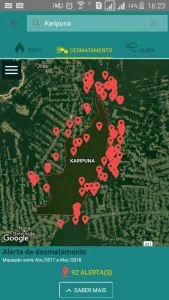
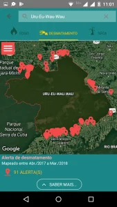
A good example is the data collected around Karipuna and Uru-Eu-Wau-Wau indigenous lands, both located in the Amazonian state of Rondônia (below). The red dots show cases registered by Imazon’s Deforestation Alert System in the last twelve months.
The proximity to indigenous lands is expected: except the protected areas and indigenous lands, Rondônia is one of the most deforested states in the Amazon, and the land use change dynamics now approaches the forest that has left.
 |
 |
Due to their culture background, Amazon indigenous people are responsible for preserving 100,000 thousand hectares, which correspond to 14 gigatons of carbon (CarbonCal, Brazil/Frel, 2015). Only 1.6 percent of their lands are deforested (PRODES/INPE, 2016).
In May, the Brazilian agency of environmental protection, IBAMA, has seized 7,387 illegally cut logs from Pirititi territory, in the state of Roraima, where non-contacted tribes still live. The affected area reaches 1,372 hectares.
Read the report “Indigenous Lands in the Brazilian Amazon: carbon stocks and barriers to deforestation“.