By Mayara Subtil*
- Report highlights that the 2026 elections could directly influence the protection of FPNDs.
- The possibility of a new intense El Niño event between 2026 and 2027 increases the risk of forest fires in the Amazon.
- Approximately 31 million hectares registered in the CAR (Rural Environmental Registry) overlap with these areas, with approximately 2.1 million hectares already deforested.
- Between January 2025 and April 2026, FPNDs accounted for 83,300 hectares of deforestation, equivalent to 20.6% of the total recorded across the land categories analyzed.
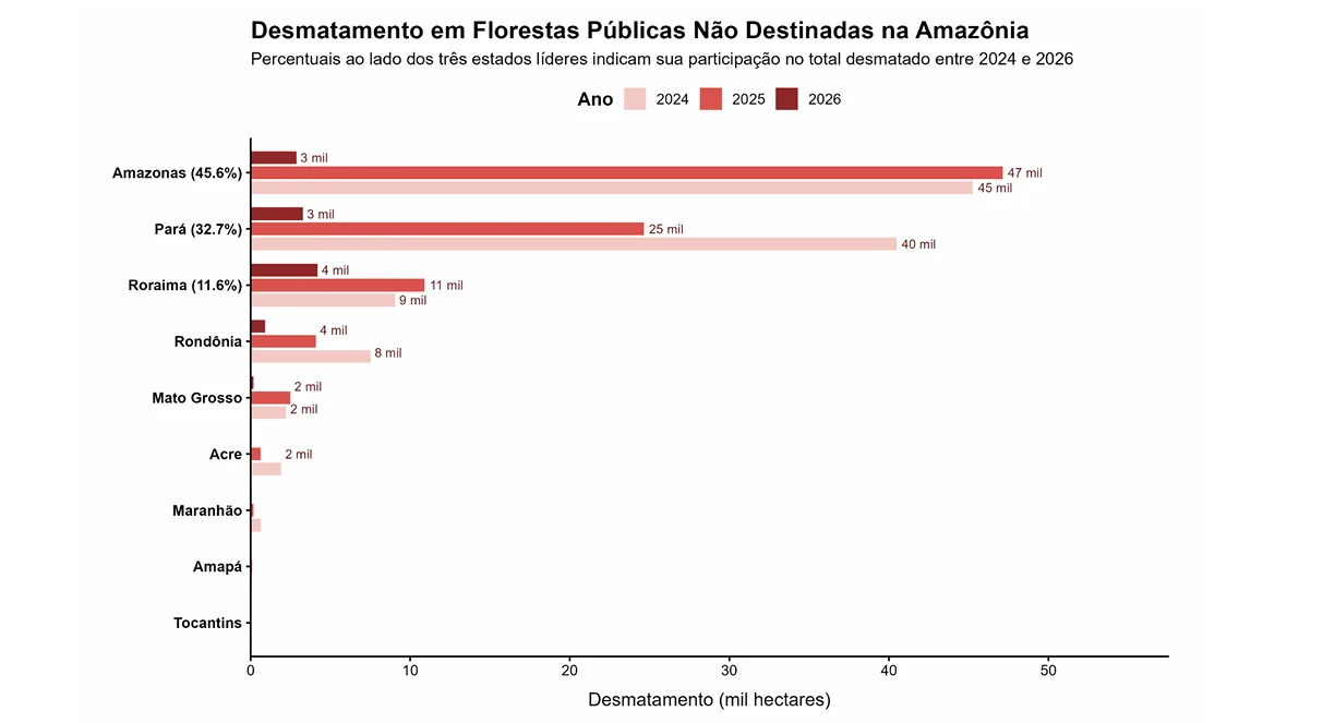
- Amazonas, Pará, and Roraima face the highest pressures from deforestation and fires.
The FPNDs (Non-Designated Public Forests) of the Amazon remain among the territories most vulnerable to the advance of deforestation, degradation, and land grabbing in Brazil. This assessment comes from the 4th bulletin of the Public Forests Observatory, released this Thursday (11). FPNDs are lands that still await an official designation for use and management by the Brazilian government. Without a designation for conservation, sustainable use, or territorial recognition, they become more susceptible to environmental crimes.
The initiative by the Amazônia de Pé movement, in partnership with IPAM (Amazon Environmental Research Institute), compiles updated data on FPNDs and, in this edition, highlights the 2026 elections as a key moment for defining public policies aimed at territorial protection and combating the effects of climate change.
The publication emphasizes that the Amazon is at risk of facing a new period of intense environmental pressure if a strong El Niño event occurs between 2026 and 2027. The phenomenon, which has already been linked to the extreme droughts and fires recorded between 2023 and 2024, is likely to become even more severe due to global warming, increasing the vulnerability of areas that are still awaiting official designation.
The next El Niño could find the Amazon even more vulnerable following a string of record-breaking heat waves and extreme weather events. In a JOTA column, experts warn that global warming tends to amplify the impacts of the phenomenon, making it even more urgent to strengthen public policies on prevention, climate adaptation, and territorial protection, especially in FPNDs.
“Designating these forests as protected areas, as already provided for by law, is one of the main strategies for reducing the impacts of extreme weather events, especially during El Niño years. It is an opportunity for the Brazilian government to combat deforestation and other growing illegal activities in the Amazon, while promoting the guarantee of rights through sustainable economies based on the forest and Amazonian culture,” stated Rebecca Maranhão, a researcher at IPAM.
Elections
The report highlights that the 2026 elections will impact the future of these forests. The text emphasizes that electing representatives without a commitment to the environmental agenda could pave the way for the weakening of institutions responsible for protecting the Amazon, as well as increase tolerance for land grabbing on public lands and hinder the advancement of policies focused on territorial governance. For Catarina Nefertari, co-executive director of Amazônia de Pé, it is necessary to expand access to information and strengthen public participation in the debate.
“In 2026, the elections are expected to coincide with an intense El Niño. While government officials must act quickly to adapt cities, civil society organizations have the role of informing the public and demanding public policies to combat the climate crisis. The bulletin ‘What’s at Stake in These Elections’ was created to provide this clarity and mobilize us for October. We often feel like hostages to decisions made behind closed doors by our political representatives. During an election period, that power lies with society. In these elections, we cannot accept candidates who ignore climate change and its impact on our lives.”
The publication argues that strengthening cooperation between federal, state, and municipal governments, integrating institutions responsible for land-use planning, and consolidating long-term public policies are essential measures to ensure the protection of FPNDs. It also cites as examples the continuation of the PPCDAm (Action Plan for the Prevention and Control of Deforestation in the Legal Amazon), the implementation of the PNMIF (National Policy for Integrated Fire Management), and actions to control irregular registrations in the CAR (Rural Environmental Registry) on public lands.
Also according to the document, expanding the state’s presence through the allocation of FPNDs and the strengthening of territorial governance can help reduce land conflicts, combat illegal activities, and increase public trust in government institutions.
Burning and Deforestation
The historical data series from the MapBiomas Fogo Network, mentioned in the bulletin, shows a growing trend in the area burned in FPNDs during dry periods, particularly in 2024, the year that recorded the highest volume since 2019. Although there was a reduction in 2025, possibly associated with the transition to La Niña conditions and the strengthening of public prevention policies, the document warns that this does not eliminate the risk of new fires, especially given the possibility of a new El Niño. About one-third of the total burned area recorded between 2019 and 2025 occurred in 2024 alone.
The publication highlights that policy choices influence the conservation of FPNDs. Changes in government, a lack of coordination between federal and state institutions, weaknesses in environmental legislation, and the pressure of land grabbing on public lands are cited as factors that accelerate the degradation of these territories.
One of the main challenges is the overlap of CAR registrations with public forests, according to the bulletin. Today, approximately 31 million hectares registered in the CAR overlap with FPNDs, of which approximately 2.1 million hectares have already been deforested. The high number of these registrations, the document states, can fuel land speculation and the spread of illegal deforestation, making it urgent to adopt measures to cancel these irregular registrations.
The survey also shows that about 78% of deforested areas in FPNDs are subsequently converted into pastures, while at least 22% evolve into secondary vegetation, which is generally degraded and more susceptible to future forest fires.
Environmental Legislation
The report warns of the risks associated with recent changes in environmental legislation. Bills that relax environmental licensing requirements, alter land regularization rules, or limit enforcement tools—such as remote seizures carried out by IBAMA (Brazilian Institute of the Environment and Renewable Natural Resources) based on satellite imagery—may reduce the state’s ability to monitor and combat illegal activities on public lands, increasing pressure on the forest and Amazonian territories.
States
The most recent monitoring data underscore the need for swift action. Between January 2025 and April 2026, FPNDs accounted for approximately 83,300 hectares of deforestation, corresponding to 20.6% of the total recorded across the land categories analyzed, according to the bulletin. The pressure from deforestation and burning is concentrated mainly in the states of Amazonas, Pará, and Roraima.
In Amazonas, the state with the largest expanse of FPNDs in the country, these areas accounted for 45% of the deforested area and 40% of the burned area accumulated between 2024 and 2026. The report also highlights that public forests located near infrastructure corridors and territorial expansion fronts are among the most vulnerable. Highways such as BR-163 in Pará, BR-174 in Roraima, as well as the Trans-Amazonian Highway and sections of BR-319 in southern Amazonas, are identified as corridors exerting significant pressure on these territories.
Allocation of FPNDs
The publication argues that the allocation of FPNDs is the primary measure to strengthen the state’s presence in the Amazon and establish permanent policies for monitoring, preventing, and combating fires. According to the bulletin, formally defining the use of these areas allows for greater accountability regarding illegal activities, enables climate adaptation mechanisms, and reduces the drivers of deforestation.
The document also points out that fire management in FPNDs still has institutional gaps. Although firefighting in federal areas is the responsibility of Ibama, through Prevfogo (the National Center for Forest Fire Prevention and Control), the lack of a clear division of responsibilities among institutions hinders preventive and coordinated actions.
Today, approximately 38% of FPNDs are under federal management and approximately 62% under state management. For the authors of the bulletin, strengthening cooperation among the different levels of government is essential to ensure integrated actions in territorial governance, environmental enforcement, and the protection of public forests.
The publication concludes that accelerating the designation of FPNDs has become a strategic measure to protect the forest, its peoples, and national sovereignty. In a context marked by the worsening climate crisis, the advance of land grabbing, and increased vulnerability to extreme events, the future of these areas will depend not only on the public policies implemented but also on the choices made by society at the ballot box.
*IPAM Communications Analyst. mayara.barbosa@ipam.org.br