Karina Custódio*
The Cerrado lost 40.5 million hectares of native vegetation between 1985 and 2024, an area larger than the territory of Spain, or twice the area of the state of Paraná. The loss corresponds to 28% of the biome’s native cover in 1985 and makes the Cerrado the second most impacted of all Brazilian biomes, behind only the Pampa. This is shown by research carried out by Collection 10 of MapBiomas, a network of organizations of which IPAM (Amazon Environmental Research Institute) is a member.
With an expansion of 22.1 million hectares, agriculture was the type of land use that grew the most in the biome, an increase of 533% in relation to its area in 1985. Pastureland increased by 14.7 million hectares (44% increase), followed by a 2.7 million hectare increase in forestry (446% increase). All types of native vegetation fell in the period, with the savannah formation being the most affected by deforestation, totaling a loss of 26.1 million hectares (a reduction of 32% compared to 1985).
“The loss of native vegetation directly compromises the resilience of the Cerrado and its populations in the face of climate change, aggravating drought scenarios and intensifying pressure on water resources, compromising the biome’s and the country’s own agricultural production in the long term,” says Ane Alencar, IPAM’s Science Director.
Four decades of changes in land use and cover
 The survey traces the profile of the biome’s use and cover in each of the four decades. In the first decade, the main driver of change was the removal of native vegetation for pasture expansion. From the second decade onwards, agriculture was the land use that most advanced over the biome, while agricultural intensification (transition from pasture to agriculture) also gained strength in the south of the Cerrado. In addition, the surface area of water fell between 2012 and 2019, growing again in 2021, thanks to the increase in the area of water in reservoirs and hydroelectric dams.
“Over four decades, the Cerrado has undergone significant transformations in land use. Until 1995, the expansion of cattle ranching was the main force of conversion, while from the 2000s onwards agriculture took center stage. These changes altered the configuration of the biome, redefining the occupation of the territory, with each decade showing distinct rhythms and patterns of transformation,” says Bárbara Costa, a research analyst at IPAM.
The period was marked by transformations in public policy, such as the creation of the Forest Code, the establishment of Cerrado Day and the strengthening of national conservation policy, with the increase in conservation units brought about by the creation of the SNUC (National System of Conservation Units).
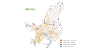
1985-1994: the decade of accelerated conversion
During this period, 15.3 million hectares of native vegetation were lost, the most deforestation of any of the four decades.
Conversion was led by the expansion of pasture (13.2 million hectares), concentrated mainly in the center-south of the biome (where DF, GO, MG, MS, MT, PR and SP are located). Agriculture was still advancing in a more localized way, with 2.2 million hectares converted directly from native vegetation, and intensification of use (conversion from pasture to agriculture) was still incipient.
It was also during this decade that Matopiba (the region comprising the states of Maranhão, Tocantins, Piauí and Bahia) began to emerge as a new agricultural frontier.
1995-2004: advance in Matopiba and drop in water surface area
The loss of native vegetation slowed down compared to the previous decade, amounting to 10 million hectares. The conversion of vegetation to pasture fell to 9.3 million hectares, still concentrated in the center-south. Of all the area cleared for agriculture in the biome, 45% was concentrated in Matopiba.
It was also during this period that, in 2001, the Cerrado recorded its lowest water surface in 40 years, 8% below the historical average.
2005-2014: deforestation slowed and intensification peaked
Despite the smallest loss of native vegetation among the four decades (5.9 million hectares less), the biome experienced its greatest transformation in land use. Agricultural intensification peaked, especially in the center-south of the biome, where 3.9 million hectares of pasture were converted into agriculture, 81% outside Matopiba.
Meanwhile, Matopiba recorded the biggest jump in the replacement of native vegetation by agriculture in four decades, totaling 1.8 million hectares, 8 out of every 10 hectares cleared for agriculture in the biome occurred in the region. Forestry also saw record growth, with 437,000 hectares of native vegetation converted.
“This period marks the consolidation of Matopiba as one of the largest and fastest deforestation and agricultural expansion fronts on the planet. It is a highly sensitive region, as it lacks protected areas and is home to the largest continuous remnants of native vegetation in the biome, which are highly threatened by this new frontier,” says Dhemerson Conciani, a researcher at IPAM.
In 2012, the Forest Code was approved, determining the conservation of up to 35% of native vegetation areas on rural properties in the Cerrado.
2015-2024: deforestation resumes
In the last decade of the survey, deforestation rose again, with 6.4 million hectares being cleared, an increase of 8% on the previous decade. Conversion to pasture remained predominant (4.9 million hectares), but at a slower rate than in previous decades. Agriculture occupied 598,000 hectares converted directly from native vegetation, 441,000 hectares of which in Matopiba.
The pattern observed in the south of the Cerrado was one of persistent intensification, totaling 1.7 million hectares of pasture turned into agriculture. After 40 years, the Cerrado still has 51% of its territory covered by native vegetation.
IPAM communications analyst, karina.sousa@ipam.org.br*